Projects:2017s1-125 Drone Imaging and Classification using Radar
Contents
Project Team
Elliot Hansen
Pranjal Chowdhury
Zikai Liu
Ran Li
Supervisors
Dr Brian Ng
Dr Waddah Al-Ashwal
Introduction
Drones have entered the modern lexicon due to their widespread uses in commercial, research and military contexts. Their prevalence is expected to increase in the coming years, with safety and privacy implications for society. The Radar is a powerful technology that provides all-weather, day-to-day capabilities to detect and target.This project explores the use of radar to perform imaging of drones, and attempts to understand the characteristics in their radar returns. Inverse synthetic aperture radar (ISAR) images will be simulated, and a radar system will be used to make real measurements of consumer drones in the School’s anechoic chamber. The outcome of this project will provide a cornerstone for building effective radar systems capable of surveillance and identification of drones.
Radar Fundamentals Radar works by using electromagnetic (EM) waves to illuminate objects in the environment and receives reflected echoes by the objects. From the received signals, the position of the targets can be measured by calculating the time taken to receive the transmitted signal. The velocity of the target can be measured by measuring the Doppler shift between the transmitted and received signal.
Inverse Synthetic Aperture Radar (ISAR) ISAR is a powerful signal-processing tool for generating 2D radar images by examining the Doppler histories of a target from its rotational movement. ISAR works using the principle that rotation of the target is equivalent to viewing the target over a circular orbit, which increase the aperture the target is viewed over. Increased aperture is directly related to an increase in resolution achievable.
Significance Regular pulse Doppler radar cannot easily identify drones, as they appear as clutter. Pulse Doppler radar struggles to detect drones from birds due to similar sizes. This project aims to find a way to detect these drones. Radar is attractive when compared to optical sensors due to its long range, all time and weather capability. Inverse synthetic aperture radar is a method which forms 2D images that can classify targets and could help governments enforce drone regulations.
Objectives
- Gain knowledge about the application of ISAR.
- Build an ISAR system capable of producing imagery of consumer drones.
- Form ISAR images of a consumer drone in an anechoic chamber.
- Analyse the images and understand the characteristics of the drones' radar returns.
Motivation
Drones have become popular in the modern world. They have many potential uses but also pose the following threats to society:
- Terrorist delivery device
- Collisions with commercial aircraft.
- Privacy concerns
Key selling points of ISAR over optical sensors:
- All weather capability
- Target and payload Identification
- Long range
Theory
ISAR exploits the rotational motion of a target to form a synthetic aperture, which increases the resolution of the images which can be formed by increasing the directivity of the antennas. A high resolution image requires a fine range resolution (Δ𝑟_𝑟=𝑐/2𝐵), requiring a large signal bandwidth (B) and a fine cross range resolution (Δ𝑟_𝑐𝑟=𝜆/2Ω), requiring a large aspect angle the target is viewed over (Ω). ISAR generates 2D images by examining the Doppler histories of a target from its movement, to separate scatterers in the cross range dimension. ISAR images cause 3D objects to be projected on a 2D imaging plane. This plane is motion dependent, therefore non-cooperative targets can form distorted images.
Approach
A National Instruments Vector Signal Transceiver was used to transmit and receive a stepped frequency chirp waveform, to provide 2GHz of signal bandwidth.
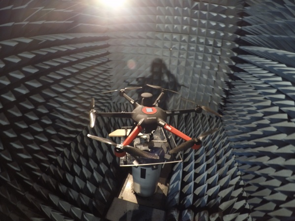
A drone was mounted on a turntable and backscattered signals were recorded at a range of different aspect angles inside an anechoic chamber. The turntable was used to apply the necessary rotational motion for ISAR imaging.
ISAR image formation involves generating a range profile using a matched filter, then taking a Fourier transform (FFT) over Doppler to form the final image.
A prominent stationary clutter source was used to apply a phase correction to the data.
ISAR images are naturally captured in a polar coordinate system, polar reformatting converts the data to a rectangular coordinate system.
Check out this video for a montage showing how we conducted the experiment.
Results
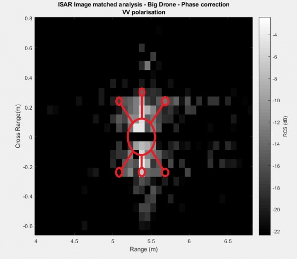
The ISAR image was generated using the radar configuration shown in the Table alongside. A scaled outline of the drone has been superimposed onto the image. Forty separate range profiles were used to generate the image. The central hub of the drone provided the strongest returns. The arms of the drone provided weaker returns. The propellers are not visible on the image.
Discussion
The drones were found to have an radar cross section of between 0.01m^2 and 0.3m^2, which means they scatter the same amount of energy as a small bird. The vertically polarised images were superior for detection and classification, due to excessive noise in the horizontal polarised images. This may have been an artefact of the experimental set up.
Zero Doppler clutter reduction and phase correction autofocus algorithms were critical for developing focused imagery. Practical challenges such as synchronised timing difficulties, phase errors, coherency difficulties and clutter within the chamber, reduced the quality of the images formed.
Conclusion
ISAR images of two drones were successfully formed. The radar system was found to be clutter limited. A commercial ISAR system for drone image should use resolutions greater than this system achieved.
Future studies
MIMO setup
Investigate phase errors
ISAR images of flying drones

